![]()
Introduction: Fiber Plant Management Challenges
If you manage your organization’s fiber plant, you know (a little too well…) that you’re in charge of a complex and incredibly intricate and hidden ecosystem full of conduits, cables, strands, splice boxes, manholes, strands, handholes…the list goes on. Not knowing what you’ve got, where it is, and what you need more of or what equipment you’ll need when you head out into the field to troubleshoot something (which creates headaches you’re probably quite familiar with). Predicting future needs and managing available resources is all but impossible.
 Visualizing your fiber infrastructure can go far beyond spreadsheets & GoogleEarth
The Evolution of Fiber Management Software
Most fiber and network managers aren’t using software specifically designed to help them manage their plant. Why? Frankly, software like that didn’t really exist in any useful way until recently (for example, we launched our fiber mapping software netTerrain back in 2017 — and it’s now used by companies of all sizes, from regional airports, colleges and universities, cities, and organizations to manage their fiber but before that, they were using spreadsheets,Visio diagrams,or GoogleEarth maps. Why have we been flooded with so many OSP customers? It’s very hard to precisely manage networks without software like netTerrain OSP — and it’s the position most fiber managers find themselves in.
Challenges in Managing Fiber Capacity and Network Expansion
Without a visual way to manage your fiber plant, it’s impossible to get capacity right. For example, is trying to manage your individual strands eat up time and lead to inaccuracy? We’ve had network managers tell us they can’t ensure accuracy and end up wasting hours of time trying to manually trace individual fiber strands within multifiber cables. What about downtime? We’ve heard — over and over — that without accurate documentation of splice points techs struggle to locate issues and fix them quickly. When they get documentation in place, they can get hours of work done in minutes. What about when your network is expanding? Maybe you manage fiber for a college or a city — without being able to see what your fiber conduits and fiber strands capacity is currently, it’s difficult to plan for the future capacity needed by your organization’s growth.
Introducing netTerrain OSP: A Solution for Fiber Mapping
Fiber mapping software like netTerrain OSP gives you the ability to create a visual map — down to the individual strand level — of your plant — from buildings to manholes to cables, strands, and equipment. This makes it easy for you to plan capacity needs, present and future, with precision. Using netTerrain OSP, for example. fiber managers who are adding in a new cable can auto-generate — which reduces the likelihood of errors and ensures that each strand is accounted for, documented, and easy to view from any web-based browser.
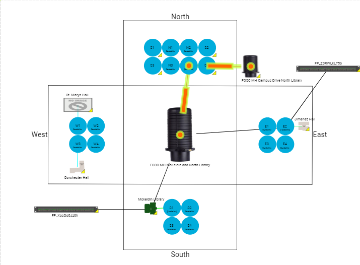
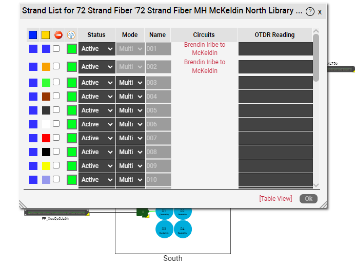 Managing your fiber down to the strand level is easy with netTerrain OSP
netTerrain’s GIS-enabled maps, connected to Google Satellite or OpenStreetMaps (OSM), make it easy to pinpoint exact locations of any element in the infrastructure that’s documented — from what’s inside manholes to what’s inside splice boxes. This makes repair, expansion, and maintenance easy, and significantly reduces downtime.
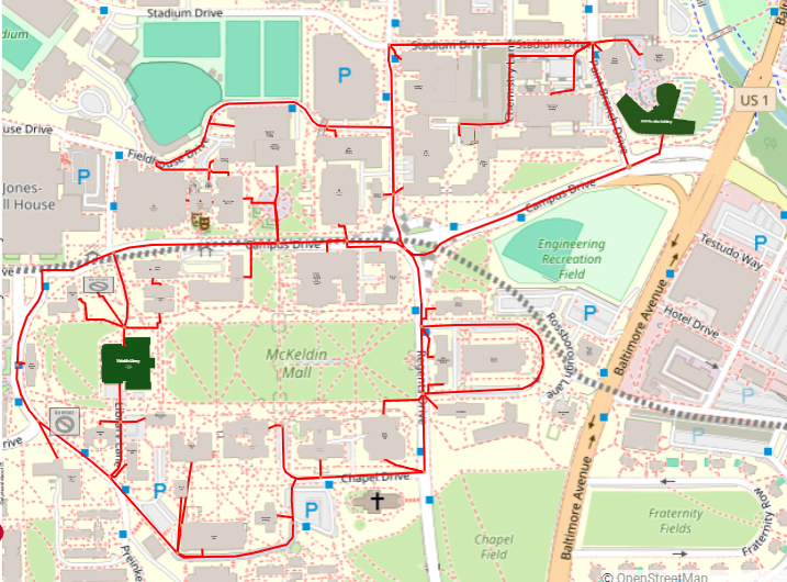 netTerrain in OpenStreetMaps
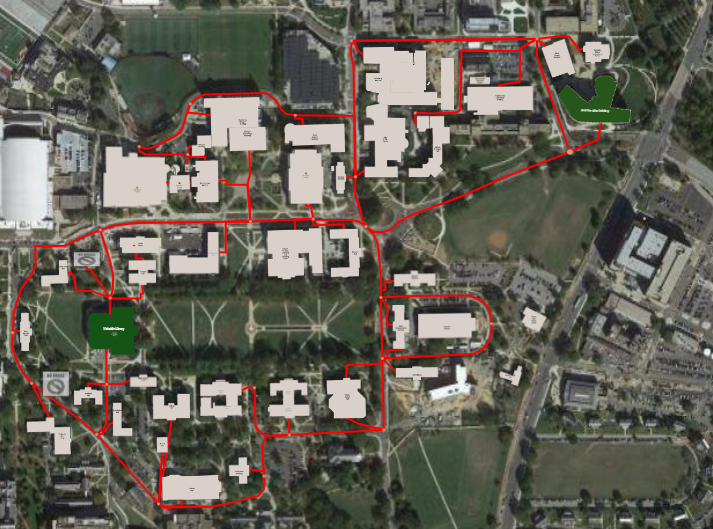 Same netTerrain diagram in Google Satellite view
Key Benefits of Using netTerrain OSP
Some of the biggest benefits of replacing your spreadsheets and GoogleEarth files with fiber mapping software like netTerrain are:
- Detailed web GIS-Enabled Maps: Having a bird’s eye view of the entire fiber infrastructure makes it easier to plan and manage both existing resources and forecast needs.
- Manage Fiber Capacity: Need to know how much fiber capacity is filled in a fiber duct or say a 144-strand fiber? Easily view occupancy fill rates for both visually as well as reports.
- Need to find an available fiber path between two buildings? Do you have fiber capacity to build new circuits, or do you need to fill out a purchase request to buy more ducts, fiber cables, and create circuit work orders for your cable installers? netTerrain has the ability to find available paths, create new circuits (with the ability to create work order tasks), build a CLR report to see the entire path of a circuit, and generate a Bill of Materials report too.
Conclusion: The Game-Changing Impact of netTerrain OSP
Bottomline? Fiber mapping software like netTerrain OSP is a game-changer if you manage a fiber plant — not just when it comes to capacity but also for efficiency, uptime, and manpower. With netTerrain in place, you get a detailed map of a once confusing labyrinth so you can ditch guesswork and accurately manage your plant — right down to the individual fiber strands. If you’re still using spreadsheets and GoogleEarth, what are you waiting for? Click here to schedule a time to book your demo and get set up with a 100% free trial of netTerrain.