
At our recent users summit, one of our customers and a partner announced they had developed their own flavor of a mobile app for netTerrain DCIM.
We will dig deeper into these implementations but, to briefly summarize: using our REST API , these customers developed a mobile app in which a user can scan devices with an RF code. They can then find that device automatically in netTerrain, look up the location, properties, and even the end-to-end connectivity — all through just using a smartphone.
It was a moment of pride for us, because of this realization: we have empowered our customers to go above and beyond the standard usage of the tool.
We did this thanks to an open, easy-to-use and well-documented API (available for all users to take advantage of). One of these users presented their version of the DCIM mobile app on our May 14th user session in front of 50 other people.
Jaws dropped and ‘oohs and aahs’ could be heard from the back of the big room (not necessarily because building something like this app is rocket science, but because it was done in a short period of time and using just the basic API which we make available for everyone).
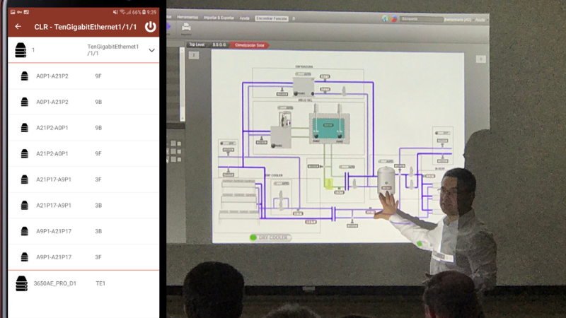 On left, app; on right, Javier Iriarte showcases the project at the May 2019 netTerrain users summit
In other blogs, we will dive into all of this in greater detail, but suffice it to say: we felt even more proud when, a few weeks after the users summit, one of the presenting customers (Acciona Energía from Pamplona, Spain) asked us if it would be possible to write up a certificate that showed that they had showcased the app during the summit.
Of course, rendering a certificate wouldn’t be a problem — but when we asked why it was needed, the manager said that the app had actually been developed by an intern and that the intern used this work as his undergrad thesis (and passed it with flying colors)! With a certificate in hand, the intern would then get a summa cum laude distinction for outstanding work in a cutting-edge field.
From an academic standpoint, this isn’t the first time that a customer has delved into the topic of Data Center Infrastructure Management using netTerrain DCIM to explore this vast topic and (literally) score extra points.
A few years back, a user that worked for one of our customers in Finland (Istekki OY), had an interesting exchange of ideas with Graphical Networks Product Management and Engineering around our roadmap and the overall direction of the DCIM market — and applied that knowledge for his masters thesis.
From an analyst’s perspective, Data Center Infrastructure Management may have had its ups and downs, but: it is still a hot topic and, in many ways, a relatively new one. In particular, when it is viewed through the lens of netTerrain DCIM, it touches on several interesting topics in computer science and telecommunications:
- Distributed real-time architectures
- REST APIs
- IT visualization (including site, building, floorplan, rack elevation and backplane rendering of data centers)
- Graphical rendering of real time data (in particular data center assets)
- Management and instrumentation protocols, such as SNMP, IPMI, WMI, SSH, Modbus, Redfish, and more
- Business rules engines
- Parsing of data (you can say big data, when it comes to real-time analysis and aggregation of performance)
- Hardware modeling and capacity forecasting
- Inventory and visualization of virtualized environments and cloud-based assets
Coupled with our other two tools (netTerrain Logical for network mapping and documentation and netTerrain OSP for fiber plant and outside plant documentation) you can even relate the above with adjacent topics such as:
- Layer 2 and layer 3 link discovery with port and subcomponent status
- Fiber mapping and GIS-based rendering of outside plant assets
- Enterprise Architecture, application and system views
In sum, if you want an honors distinction for an academic project and DCIM piques your interest, then look no further: netTerrain DCIM gives you a real-life pane of glass into all the major DCIM functions in an easy-to-use, graphically appealing package with an extensible SOAP and REST API.