It’s Tuesday afternoon and an email from the city manager lands in your inbox: “We’re finalizing the new fire station’s backbone connection. Can you send over the strand map and available fiber paths by Thursday?” You open the shared drive. There’s a Visio from 2018, a spreadsheet that hasn’t been touched since the last contractor left, and a Google Earth KML file that may—or may not—match what’s actually in the ground. Your most reliable source of truth is the senior tech who’s been here for twenty years and is taking a long-awaited vacation next week.
You’re not alone. If you’re responsible for IT infrastructure in a municipal government, you already know that accurate, up-to-date fiber documentation is rarely something you can simply pull up. You’ve learned to expect guesswork.
The real cost of scattered infrastructure knowledge isn’t just inconvenience. It’s time. It’s the hours spent driving out to a handhole just to verify which strands are live. It’s the Saturday mornings re-drawing diagrams because a grant proposal needs a “current network map.” It’s the quiet anxiety that when a 911 dispatch center fiber goes dark, you’ll be tracing circuits by flashlight and hand-drawn notes. For a small team—often just a handful of people managing everything from police radios to library Wi-Fi—the documentation debt piles up fast. And because you chose municipal IT for stability, public impact, and a life outside of work, constant documentation firefighting not only threatens your sanity but also the work-life balance you value.
You’ve heard your own team say it: “We don’t know what assets we really own.” Bureaucracy doesn’t help, either. You’ve sat through meetings where a simple network expansion gets bogged down for months because no one can agree on what infrastructure already exists. You’ve inherited as-builts from contractors that are accurate on day one but outdated by the time they’re filed. And you’ve felt the frustration of knowing that with the right tool, you could answer leadership’s questions in minutes—and finally show them that IT isn’t a cost center, but the backbone that keeps public safety, utilities, and city services running smoothly. That’s how you earn respect in budget meetings where everybody else thinks IT is just a line item.
It doesn’t have to be a scramble every time. Cities like Seguin are finding a way out of documentation chaos by choosing a system that doesn’t just draw pretty pictures but actually connects the physical world of fiber and conduit to the logical world of switches, ports, and circuits. netTerrain is that system—a visual infrastructure platform well suited for municipalities that are tired of guessing.
netTerrain helps municipalities bring physical and logical infrastructure into one visual documentation environment. Teams can document fiber routes, conduits, handholes, splice points, strands, circuits, devices, ports, and rack layouts, while also working with georeferenced OSP views and citywide maps. Existing data can be brought in through supported import workflows such as Excel, Visio, KML/KMZ, and ArcGIS import, helping teams avoid starting from scratch. For lean municipal IT teams, that can mean less reliance on scattered spreadsheets, outdated drawings, and field verification trips—and more confidence when planning expansions, troubleshooting outages, or answering leadership’s infrastructure questions. Custom devices can be modeled using netTerrain’s included modeling tools, with support from Graphical Networks when needed.
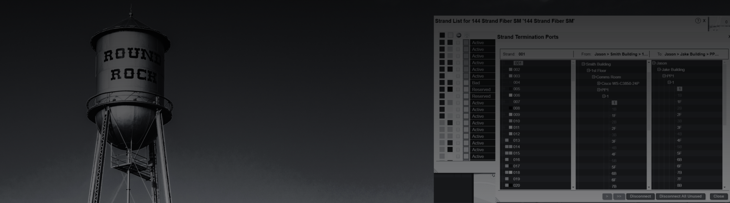
netTerrain satellite campus map view showing detailed strand-level documentation, splice points, ports, and termination information.
What does that actually feel like in practice? It means that when the city manager asks for a strand map, you can bring up a georeferenced view showing splices, patch panel ports, circuits, and terminations—from the street toward the endpoint. With accurate strand and circuit data in netTerrain, teams can identify available paths and plan new connections with more confidence. It means you stop burning afternoons driving to sites just to look at a patch panel label. No more sending your best people on guesswork treks into the field.
The City of Seguin, Texas, knows that shift firsthand. Seguin is home to 30,000 residents, spread across 38 square miles, with an IT team of just eleven people juggling multiple large projects. Before netTerrain, they relied on spreadsheets, paper drawings, and Visio. Getting basic information often meant physically trekking out to field locations. As they put it, “Manual documentation was increasingly challenging to manage and keep up-to-date.” Read the case study and others here.

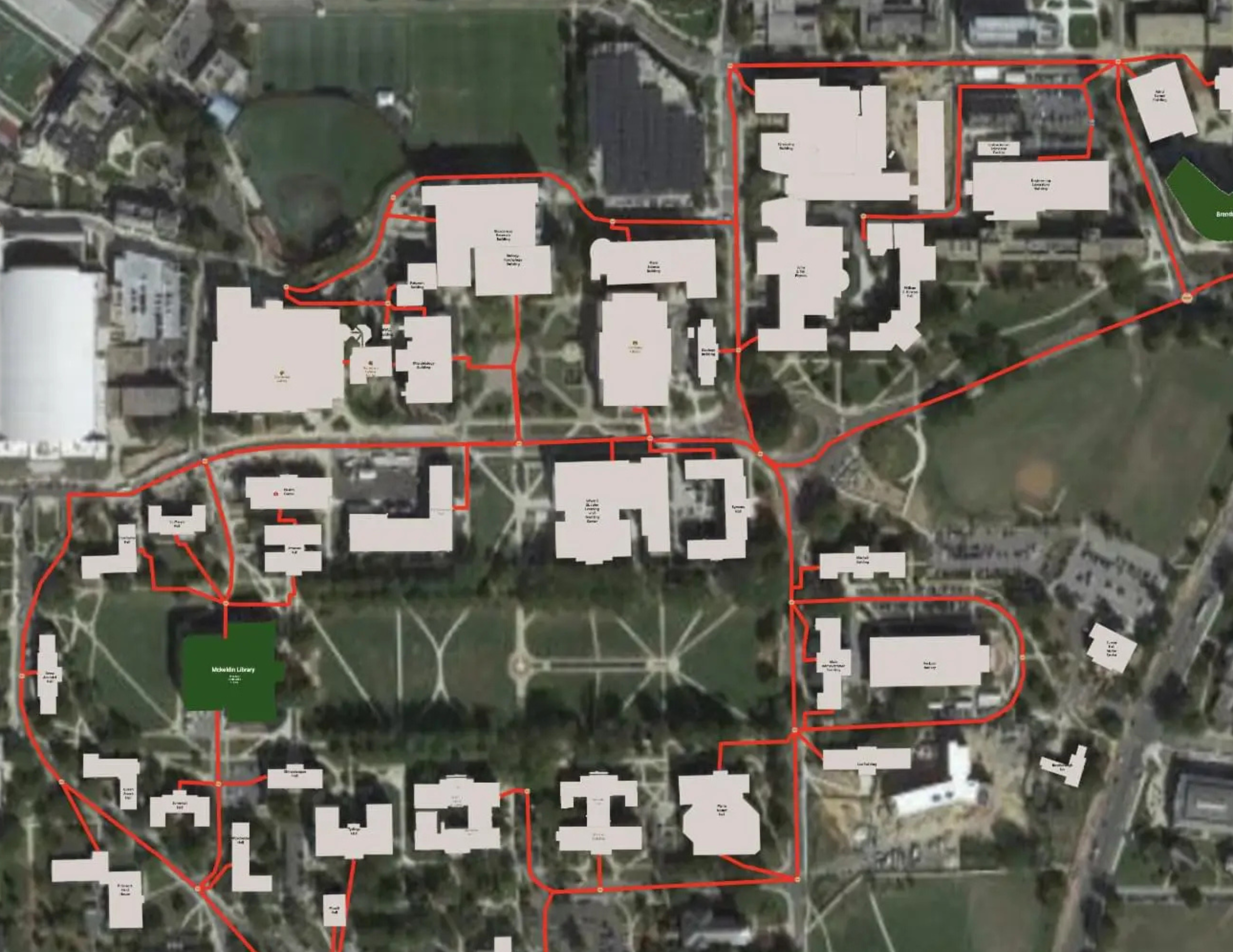
netTerrain makes seeing and understanding IT—from the street level to the strand level—easy.
They chose netTerrain because it could handle the intricate strand-level detail of their fiber optic network, was easy to adopt without a huge learning curve, and fit a municipal budget. Today, Seguin’s team has a complete street-to-strand view of both aerial and underground fiber. They can pinpoint termination locations and slack areas in clicks, plan new infrastructure with confidence, and collaborate across departments without chasing down tribal knowledge. Justin Ramirez, the city’s IT manager, says it best: “We gained a complete view of our infrastructure and the location of our assets. It’s more than just documentation; we now have the capability to accurately and precisely plan for projects, expansions, and new construction.”
If you’re ready to stop guessing and start seeing your city’s fiber and network clearly—without disrupting your team’s workload or your own sanity—take the smallest possible step. Book a 15-minute discovery call. We’ll walk through what you’re dealing with today, show you how netTerrain could pull it all together, and let you decide if it’s worth a closer look. No pressure, no hype. Just a real conversation about a tool that’s already helping cities like Seguin turn infrastructure chaos into operational clarity.