Our customers asked for it – and we delivered: a solution for documenting wireless and fiber optic networks. With the release of netTerrain 6.6, netTerrain Outside Plant (OSP) software is live.
In this introductory blog to our new series on Outside Plant software, we’ll give you an overview of what netTerrain OSP is and how it may be a powerful tool for managing your assets and their connections wherever they happen to be.
netTerrain with Outside Plant: A Comprehensive Solution
What, exactly, is netTerrain OSP? It’s an add-on module that turns your existing netTerrain software (whether it’s netTerrain Logical for network documentation, netTerrain DCIM for data center infrastructure management) into outside plant software with all of the flexibility and customization that our customers expect from netTerrain.
netTerrain OSP, Logical, DCIM: IT Visualization Software Without the Red Tape
In general, we dislike software that pigeonholes its users with limitations – and far too many solutions today do just that. Some examples: bloated software with useless features and not enough wiggle room, thick clients and plug-ins, overly complicated interfaces and structures that force users to find time-consuming and inefficient workarounds…
Software should respond to users’ needs, not the other way around. We pride ourselves on crafting the most flexible IT visualizations on the market – and netTerrain OSP does not disappoint.
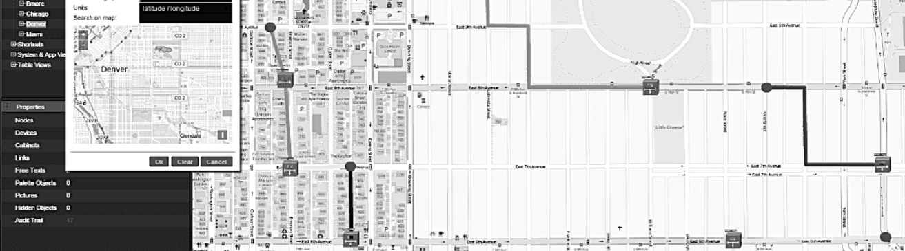
In subsequent blog posts, we’ll go into greater detail about just how netTerrain OSP pairs flexibility and usability with powerful management, but here’s a look at what it can do:
- Zoom in from the world view to the building level with fully GIS-enabled maps that are updated daily.
- Improve your connection utilization and streamline capacity through end-to-end circuits and circuit layout records that show you full connectivity paths – including the inside and outside plant hierarchies for each segment.
- Hierarchically map all OSP elements according to your own layers (such as fiber strands in buffers in ducts in conduits, or connection points with splitters with manholes, etc).
- Manage towers, antennas, radio equipment, wireless connections and more.
- Reduce downtime by quickly identifying end-to-end connections.
- Pinpoint exact locations of each connection segment and element.
- Find any attributes you like in seconds with our quick search function.
- Create circuits with simple drag and drops and map each assigned path down to the port level.
- Attach any documents to your OSP elements and manage them like you do in SharePoint.
- Any object you need can be added – from manholes to antennas to ducts to custom ones you create in seconds…in the video below, using netTerrain DCIM as an example, you how simple it is to create custom objects in netTerrain:
Up Next
Tune in for the next blog post in this series in which we’ll give you a bird’s eye view of dynamic maps (and we’ll be discussing the pro’s and con’s for mapping your outside plant).